Tropical Depression Edouard was dropping heavy rain on parts of southeast Texas on Wednesday morning. At 5:00 a.m. EDT on Wednesday the center of Tropical Depression Edouard was located at latitude 30.8°N and longitude 95.0°W which put the center about 30 miles (50 km) south-southwest of Lufkin, Texas. Edouard was moving toward the north-northwest at 5 m.p.h. (8 km/h). The maximum sustained wind speed was 35 m.p.h. (55 km/h) and there were wind gusts to 45 m.p.h. (75 km/h). The minimum surface pressure was 1004 mb.
Tropical Depression Edouard was dropping heavy rain on parts of southeast Texas on Wednesday morning. A radar image from the U.S. National Weather Service Office in Houston showed that the circulation around Edouard was still very well organized.
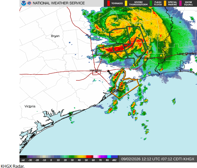
Flash Flood Warnings are in effect for East Central San Jacinto County, Southeastern Polk County, and Northeastern Liberty County.
A well defined center of circulation was evident in Tropical Depression Edouard. Bands of showers and thunderstorms were revolving around the center of Edouard’s circulation. The heaviest rain was falling in a band that was south of the center of Tropical Depression Edouard. Moderate to heavy rain falling near the center of Edouard’s circulation. Moderate to heavy rain was also falling south and east of the center of Tropical Depression Edouard.
Tropical Depression Edouard will move around the southwestern part of a high pressure system that is over the Southeast U.S. The high pressure system will steer Edouard slowly toward the north-northwest during the next 24 hours. On its anticipated track, Tropical Depression Edouard will continue to move farther inland over southeast Texas.
Tropical Storm Edouard will continue to drop heavy rain to parts of southeast Texas. Heavy rain could cause flash floods in some locations.
A Flood Watch is in effect for parts of southeast Texas.

